
HomeBlogsExample ItinerariesWestern Canada: Rockies & Vancouver Island in 2...
Western Canada: Rockies & Vancouver Island in 21 Days

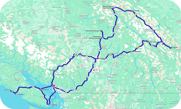
Western Canada is well suited to a longer RV trip, combining the Pacific coast, mountain landscapes, and Vancouver Island in one route. Over 21 days, you’ll travel from Vancouver through Whistler and the Canadian Rockies before returning west and crossing to Vancouver Island.
Along the way, you’ll drive the Sea-to-Sky Highway and Icefields Parkway, visit waterfalls in Wells Gray Provincial Park, spend several days around Jasper and Banff, and cross Vancouver Island to Tofino. The final days take you along the Pacific coast and to Victoria before you return to Vancouver. Several two- and three-night stays keep the pace comfortable. You’ll have time for hiking, sightseeing, and quieter days without changing campgrounds every morning.
Plan your first night in Vancouver before collecting your RV. After that, start your road trip with an RV rental in Vancouver.
Day 1: Vancouver
Start your trip in Vancouver and use the first day to explore the city. Stanley Park is a good place to begin: walk or cycle part of the seawall for views across Burrard Inlet toward the North Shore Mountains. From there, continue along the waterfront toward Canada Place or head to Granville Island for its public market, small shops, and restaurants. Gastown is another easy addition if you have time. Keep your schedule flexible, especially after a long flight, as you’ll collect your RV tomorrow.
Day 2: Vancouver – Whistler, approx. 75 mi (120 km) – 2 hours
Collect your RV and follow Highway 99 north toward Whistler. The Sea-to-Sky Highway runs alongside Howe Sound before climbing into the Coast Mountains, so allow time to stop along the way. Shannon Falls is an easy break, with a short walk from the parking area to viewpoints near the waterfall. Continue to Whistler and set up at your campground. Since the drive is relatively short, you should still have time to explore Whistler Village or walk around one of the nearby lakes.
Day 3: Whistler and Garibaldi Provincial Park
Spend a full day around Whistler and choose how active you want to make it. Hikers can head into Garibaldi Provincial Park, where trails lead through the Coast Mountains toward glacier-fed lakes and alpine terrain. Garibaldi Lake is one of the best-known destinations, but reaching the lake from the Rubble Creek trailhead requires a substantial hike, so allow most of the day and check current trail conditions and day-use pass requirements before setting out.
For a less demanding day, stay closer to Whistler and follow part of the Valley Trail, walk around Lost Lake, or explore Whistler Village. During the summer operating season, the PEAK 2 PEAK Gondola is another option for reaching the alpine environment without committing to a long hike. With two nights in Whistler, you can choose the experience that suits you rather than trying to combine everything in one day.
Day 4: Whistler – Clearwater, approx. 260 mi (420 km) – 6 hours
Leave Whistler and continue toward Clearwater. This is one of the longer driving days, but the landscape changes considerably along the way as the Coast Mountains give way to valleys and the interior of British Columbia. Take regular breaks rather than adding a long list of sightseeing stops to the day. Arrive in Clearwater later in the afternoon and settle into your campground. Tomorrow is reserved for Wells Gray Provincial Park.
Day 5: Wells Gray Provincial Park
Spend the day exploring Wells Gray Provincial Park, known for its rivers, forests, and waterfalls. Start at Helmcken Falls, where the Murtle River drops about 463 ft (141 m) into a canyon. Continue to Dawson Falls, where the river spreads across a broad rock ledge. Several shorter trails and viewpoints can be combined with these stops, depending on current conditions and how much walking you want to do. Return to your campground around Clearwater at the end of the day.
Day 6: Clearwater – Jasper, approx. 200 mi (320 km) – 4.5 hours
Continue east toward the Canadian Rockies. Mount Robson Provincial Park makes a logical stop along the route. At 12,972 ft (3,954 m), Mount Robson is the highest peak in the Canadian Rockies and rises prominently above the surrounding valleys when the weather is clear. Stop for a short walk or lunch before continuing into Alberta and Jasper National Park. Settle into your campground around Jasper for three nights.
Day 7: Jasper National Park
Use your first full day to explore the area around Maligne Lake, a long mountain lake surrounded by peaks and forest. Walk along the shoreline or take a boat trip when services are operating. If you prefer to stay closer to Jasper, Pyramid Lake and Patricia Lake are easy to combine and offer shorter walks, picnic areas, and mountain views. Renting a canoe or kayak is another way to spend some time on the water where rentals are available. Focus on one part of the park rather than trying to cover everything in a day; distances are substantial and wildlife or sightseeing stops often add time.


Day 8: Jasper National Park
Keep a second full day for another part of Jasper National Park. Athabasca Falls is a good place to start, where the Athabasca River passes through a narrow gorge below the falls. Walking paths connect several viewpoints around the river. From there, choose a hiking trail, explore more of the Athabasca Valley, or spend a quieter afternoon around one of the lakes near Jasper. Two full days also give you some flexibility if mountain weather changes. Check current Parks Canada information before your visit, as recovery from the 2024 wildfire continues to affect some locations and services.
Day 9: Jasper – Lake Louise via the Icefields Parkway, approx. 145 mi (235 km) – 3.5 hours driving
Set aside most of the day for the Icefields Parkway. The direct drive takes around 3.5 hours, but Highway 93 passes waterfalls, glaciers, mountain valleys, and several viewpoints worth stopping for. Sunwapta Falls is one option before you reach the Columbia Icefield area, where glaciers descend from the surrounding peaks. Farther south, stop at Peyto Lake for the elevated viewpoint over the blue-green lake and valley below. Fill your fuel tank before leaving Jasper and avoid planning too many fixed activities; short walks and viewpoints can easily turn this into a full-day journey. Continue to the Lake Louise area in the late afternoon.
Day 10: Lake Louise and Moraine Lake
Dedicate today to Lake Louise and Moraine Lake rather than adding another driving day. At Lake Louise, walk along the lakeshore below Victoria Glacier or choose one of the trails climbing into the surrounding mountains. If you want to spend more time walking, there are routes ranging from easy lakeside paths to longer hikes into the surrounding alpine terrain. Moraine Lake lies nearby in the Valley of the Ten Peaks, but personal vehicles are not permitted on Moraine Lake Road. Use a Parks Canada shuttle, public transit, or an authorized commercial operator and arrange transportation ahead when required. Both lakes deserve time, so choose your walks carefully instead of trying to combine several longer hikes in one day.
Day 11: Lake Louise – Banff, approx. 37 mi (60 km) – 45 min.
Leave Lake Louise for the short drive to Banff. Since you have less than an hour of direct driving, use the rest of the day to get to know the town and its surroundings. Walk through downtown Banff and continue toward the Bow River, or choose one of the nearby viewpoints or shorter trails. Settle into your campground for three nights. Using one base for several days makes exploring this part of Banff National Park easier with an RV.
Day 12: Banff National Park
Explore the area around Banff today. Lake Minnewanka is a good starting point, with lakeshore trails, picnic areas, and boat trips during the operating season. You can combine the lake with other nearby stops or choose a longer hike elsewhere in the Bow Valley. If you prefer a slower day, spend the morning outdoors and return to Banff for the afternoon. Parking at popular locations can fill early in summer, so check local transit options before moving a larger RV between busy areas.
Day 13: Banff National Park
A second full day gives you freedom to explore another part of Banff National Park or return to somewhere you missed because of weather. Choose a longer hike, spend more time in the Bow Valley, or simply keep part of the day free. If you want a different perspective on the mountains, the Banff Gondola is another option for reaching Sulphur Mountain without making it a full hiking day. Three nights around Banff mean you don’t need to spend every hour sightseeing. The Rockies are a central part of this trip, and an extra day here makes more sense than adding another overnight destination.
Day 14: Banff – Revelstoke, approx. 175 mi (280 km) – 3.5 hours
Follow the Trans-Canada Highway west into British Columbia. The route passes through Yoho National Park before continuing across Rogers Pass in the Selkirk Mountains. Stop at Emerald Lake if time allows. A walking trail follows the shoreline, or you can simply stop for a shorter look at the lake and surrounding mountains. Continue through Rogers Pass and descend toward Revelstoke, where you’ll spend the night before the longer drive back to the coast.
Day 15: Revelstoke – Vancouver area, approx. 350 mi (565 km) – 6.5 hours
Leave Revelstoke early for the longest driving day of the route. The journey takes you west across southern British Columbia toward the Lower Mainland. Keep the day straightforward and take regular breaks rather than trying to add several attractions along the way. Mountain roads, construction, traffic, and weather can affect the actual travel time. Stay in the Vancouver area tonight, which avoids combining a long drive with a ferry crossing and the road to Tofino.
Day 16: Vancouver area – Nanaimo – Tofino, approx. 140 mi (225 km) – 4 hours driving plus ferry
Head to the ferry terminal and cross the Strait of Georgia to Nanaimo on Vancouver Island. From Nanaimo, Highway 4 takes you across the island toward Tofino. Forests, lakes, and mountain terrain line the route, and the final section toward the west coast has plenty of bends, so allow more time than the distance alone suggests. Arrive around Tofino and settle in for three nights. You now have two complete days to explore without moving camp.
Day 17: Tofino and Pacific Rim National Park Reserve
Spend your first full day on Vancouver Island’s Pacific coast. Between Tofino and Ucluelet, Pacific Rim National Park Reserve protects sandy beaches, coastal forest, and temperate rainforest. Start around Long Beach and walk along the shoreline before exploring one of the rainforest trails. Later, return to Tofino. If you want to get out on the water, this is a good place to try a guided kayaking trip, join a wildlife-watching excursion, or take a surfing lesson. You have another full day here tomorrow, so choose one activity and leave enough time for the beach and town.
Day 18: Tofino and Ucluelet
Head south toward Ucluelet for another day along the coast. Sections of the Wild Pacific Trail follow rocky headlands and forest with views across the Pacific. Stop at beaches and forest trails between Ucluelet and Tofino rather than trying to fit too many places into the day. Weather changes quickly here, so having a second full day on the west coast also gives you flexibility to return to Long Beach or another place you missed yesterday.
Day 19: Tofino – Victoria, approx. 195 mi (315 km) – 5 hours
Leave Tofino and follow Highway 4 back toward the east coast of Vancouver Island before turning south to Victoria. Break up the drive around Parksville or Nanaimo, or stop in the Cowichan Valley farther south. There is no need for a major excursion today; with around five hours of driving, a few well-timed breaks keep the journey comfortable. Arrive at your campground in the Victoria area and stay for two nights.
Day 20: Victoria
Leave the RV parked if practical and spend the day exploring Victoria on foot. Start around the Inner Harbour, where the Parliament Buildings and several historic streets are close together. Continue along the waterfront toward Fisherman’s Wharf or walk through Beacon Hill Park. If you want to see more of the coastline, you could also use part of the day for a whale-watching trip from Victoria before returning to the city. Central Victoria is compact, so there is no need to move the RV between individual sights.
Day 21: Victoria – Vancouver, approx. 45 mi (70 km) – 1.5 hours driving plus ferry
Drive north to the Swartz Bay ferry terminal and cross to Tsawwassen on the mainland. From there, continue to your RV rental location in the Vancouver area. Allow enough time for ferry check-in, the crossing, traffic, refueling, and the vehicle return. After three weeks, you finish where you started, having combined Vancouver, the Canadian Rockies, and Vancouver Island in one RV route without changing campgrounds every day.
Want to travel this route yourself? Explore RV rental in Canada and the options for RV rental in Vancouver to start planning your trip.


Practical information for this route
-
Travel period: Summer and early fall are the most practical periods for the complete route. Mountain roads, campgrounds, trails, and visitor services can have seasonal opening dates.
-
Campgrounds: Reserve popular campgrounds ahead, particularly around Jasper, Lake Louise, Banff, and Tofino during summer. Multi-night stays mean you can keep the same campground while exploring each area.
-
Jasper: Recovery from the 2024 wildfire continues to affect some locations and services. Check current Parks Canada information shortly before traveling.
-
Icefields Parkway: Fill your fuel tank before departure and allow most of the day between Jasper and Lake Louise. Services are limited, and stops along the route make the journey much longer than the direct driving time.
-
Lake Louise and Moraine Lake: Personal vehicles are not permitted on Moraine Lake Road. Check current shuttle and public transportation arrangements before your visit. Access and parking around Lake Louise are also managed during busy periods.
-
Ferries: The route includes two ferry crossings between the Vancouver area and Vancouver Island. Reserve vehicle space ahead during popular travel periods and enter the correct RV dimensions when booking.
-
Road conditions: Check current conditions before longer driving days, particularly through the mountains and on Highway 4 toward Tofino.
-
Wildlife: Bears, elk, deer, and other wildlife live throughout the route. Keep your distance and follow food and garbage storage requirements at campgrounds.
-
Weather: Bring layers and waterproof clothing. Conditions on Vancouver Island’s Pacific coast can differ considerably from higher elevations in the Rockies.
-
Driving times: Driving times are approximate and exclude sightseeing stops, ferry waiting times, construction, and longer breaks. The Icefields Parkway in particular should be treated as a full sightseeing day rather than a simple transfer.