
HomeBlogsExample ItinerariesNew Zealand: Discover the South Island by RV
New Zealand: Discover the South Island by RV

New Zealand’s South Island is a great place to explore by camper. In two weeks, the scenery changes from open farmland and bright blue lakes to high mountains, deep fjords, rainforest and the wild West Coast. The island is also known as Te Waipounamu in te reo Māori and has a strong connection with Ngāi Tahu, the main Māori iwi of the South Island. Along the way, you will come across some of this heritage alongside gold-rush history, small towns and some of New Zealand’s darkest night skies.
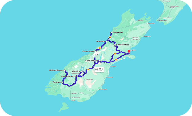
This 15-day road trip starts and ends in Christchurch. From there, you travel to Lake Tekapo and Aoraki/Mount Cook before heading south to Queenstown, Te Anau and Milford Sound. The route then turns north through Wānaka and crosses Haast Pass to the West Coast. After visiting Franz Josef, Hokitika and Punakaiki, the journey through Arthur’s Pass brings you back across the mountains to Christchurch.
Day 1: Christchurch
Christchurch is a comfortable place to begin your South Island camper trip. The Botanic Gardens and city center are easy to explore, while a stroll beside the Avon River/Ōtākaro gives you a first look at the city. This is also a useful time to buy groceries and prepare your camper. If you arrive after a long international flight, an overnight stay in Christchurch can make for an easier start before getting used to driving on the left.
You can compare options for RV rental in Christchurch before starting the route.
Day 2: Christchurch – Lake Tekapo, approx. 140 mi (225 km) – 3 hours
Leaving Christchurch behind, the route crosses the farmland of Canterbury before the Southern Alps begin to appear in the distance. The landscape becomes increasingly open as you approach Lake Tekapo. Once there, you can spend some time beside the lake and visit the small Church of the Good Shepherd. After sunset, Lake Tekapo offers a completely different experience. It lies within the Aoraki Mackenzie International Dark Sky Reserve, an area protected from light pollution and known for exceptionally dark skies.
On a clear night, you can find a dark place and simply look up or join a guided stargazing experience. Mount John above the lake is home to a professional astronomical observatory, while some local experiences combine modern astronomy with Māori knowledge of the night sky.
Tip for Matariki: If you travel during the New Zealand winter, your visit may coincide with Matariki, the Māori New Year. Matariki is connected with a group of stars that appears in the morning sky and is a time for remembering the past, celebrating the present and looking ahead. Events vary each year, so check what is happening locally during your stay.
Day 3: Lake Tekapo – Aoraki/Mount Cook, approx. 65 mi (105 km) – 1.5 hours
Today’s drive is relatively short, giving you plenty of time to enjoy the journey. For part of the route, the road follows the bright blue water of Lake Pukaki, with views toward the mountains when the weather is clear.
Aoraki/Mount Cook is New Zealand’s highest mountain and an important place in Ngāi Tahu culture. The village sits deep within the alpine landscape, surrounded by peaks, valleys and glaciers. After arriving, you have time to get your first look around before spending a full day in the national park tomorrow.
Day 4: Aoraki/Mount Cook
With no major driving planned, you have the day to experience Aoraki/Mount Cook National Park at your own pace. You could follow one of the routes into the valleys, visit a glacier viewpoint or stay closer to the village and enjoy the mountain scenery.
The second night also gives you more flexibility with the weather. Conditions and visibility can change quickly here, so the latest weather and track information can help when making plans for the day.
Day 5: Aoraki/Mount Cook – Queenstown, approx. 165 mi (265 km) – 3.5 hours
Mountain scenery gradually gives way to drier hills as the route heads south toward Queenstown. The journey crosses Lindis Pass, where the road winds through broad grass-covered hills before continuing toward Central Otago. Queenstown sits beside Lake Wakatipu with mountains rising around the town. After arriving, you can explore the waterfront, find somewhere for dinner or simply get a first feel for the town before having a full day here tomorrow.
Day 6: Queenstown
Queenstown offers a wide choice of activities, from outdoor adventures to quieter ways of enjoying Lake Wakatipu. Jet boating is one of the area's well-known experiences, while a lake cruise, cycling or time around the waterfront show different sides of the town and its surroundings.
Arrowtown is another possibility for today. The historic town lies a short drive from Queenstown and grew during the Otago gold rush of the 1860s. Old buildings remain around the center, while the preserved Chinese Settlement tells part of the story of Chinese miners who came to the region during the gold rush.


Day 7: Queenstown – Te Anau, approx. 106 mi (170 km) – 2.5 hours
For the first part of the journey south, Lake Wakatipu stays close to the road before the route continues across quieter countryside. Te Anau sits beside a large lake and is the main starting point for road trips into Fiordland. After arriving, there is time to see the lakeside and small town center. Te Anau is also the main place to buy groceries and fill the camper with fuel before the Milford Sound excursion, as there are no shops or fuel stations between Te Anau and Milford Sound.
Day 8: Te Anau – Piopiotahi/Milford Sound – Te Anau, approx. 150 mi (240 km) – at least 4 hours driving
The Milford Road is part of the experience today. Forest, rivers, broad valleys and steep mountains surround the route, and places such as the Eglinton Valley and Mirror Lakes are easy to include along the way.
Milford Sound, also known by its Māori name Piopiotahi, lies about 75 mi (120 km) from Te Anau. The drive takes around two hours each way without stops, but there is plenty to see between the two. A popular way to explore the fjord is by boat. From the water, the scale of the landscape becomes much clearer, with mountains rising steeply from the shoreline and waterfalls dropping down the cliffs, particularly after rain.
Food and drinks are useful to bring from Te Anau, and insect repellent can come in handy as well. Fiordland weather can change quickly, so check current road conditions before departure.
Day 9: Te Anau – Wānaka, approx. 170 mi (275 km) – 4 hours
The route turns north again today, taking you back toward the Queenstown area before continuing to Wānaka. Although it is a longer transfer, the scenery changes considerably along the way and by the time you arrive, the mountains and Lake Wānaka create a very different setting from Fiordland. The lakefront, town center, cafés and outdoor activities give you several possibilities for the rest of the day.
Day 10: Wānaka – Franz Josef/Waiau, approx. 177 mi (284 km) – 4 hours
Today brings one of the biggest changes in landscape on the route. From the alpine lake country around Wānaka, the Haast Highway crosses Mount Aspiring National Park before descending toward the wetter western side of the South Island.
Near Makarora, the Blue Pools Track leads through native beech forest to clear river pools and can be included as a stop along the journey. Farther west, waterfalls, rivers and dense rainforest begin to dominate the scenery. After Haast, the road turns north and follows the West Coast toward Franz Josef/Waiau.
Day 11: Franz Josef/Waiau
Franz Josef is one of the places where the West Coast landscape feels particularly distinctive. Temperate rainforest grows close to the mountains, while the Franz Josef Glacier descends from the Southern Alps above.
You can see the glacier environment from the valley or experience it from above on a scenic flight. Guided glacier experiences are another possibility when weather and conditions allow. Having a second night here is useful because West Coast weather can change quickly. Rainforest, rivers and the small town itself provide alternatives when cloud or rain limits views toward the mountains.
Day 12: Franz Josef/Waiau – Hokitika, approx. 85 mi (135 km) – 2 hours
The journey continues north through the green landscapes of the West Coast. With only around two hours of driving, you reach Hokitika with plenty of the day remaining. The town is particularly known for pounamu, or New Zealand greenstone, which has deep importance in Ngāi Tahu culture. Galleries and carving studios provide an opportunity to see how it is worked and learn more about its significance. Hokitika sits directly beside the Tasman Sea, and its beach and small town center give the stop a noticeably different character from Franz Josef.
Day 13: Hokitika – Punakaiki, approx. 55 mi (85 km) – 1 hr 15 min
North of Hokitika, the highway eventually reaches a dramatic coastal section where the Tasman Sea lies beside forest-covered hills.
At Punakaiki, layers of limestone have formed the unusual Pancake Rocks. When sea and tide conditions are right, waves force water through natural blowholes between the rocks. A path through the formations gives you views of both the limestone and coastline.
This settlement also sits beside Paparoa National Park, where rainforest, limestone formations and the coast come together in a relatively small area.


Day 14: Punakaiki – Arthur’s Pass, approx. 90 mi (145 km) – 2 hours
After several days beside the West Coast, the road turns inland toward the Southern Alps. Rainforest and river valleys gradually give way to higher mountain scenery as you approach Arthur’s Pass.
Around the village, you can spend some time in the alpine surroundings or head out on one of the nearby tracks. You may also encounter a kea, New Zealand’s curious alpine parrot. Keep food and loose belongings secure around the camper and never feed them.
Day 15: Arthur’s Pass – Christchurch, approx. 95 mi (150 km) – 2 hours
The final drive leaves the mountains behind and heads toward the Canterbury Plains. The landscape gradually becomes flatter as you travel east and the roundtrip returns to Christchurch. Allow enough time for refueling and returning the camper according to your rental arrangements. Depending on your flight schedule, an additional night in Christchurch can also be a convenient way to finish the journey.
Fifteen days gives you a varied introduction to the South Island, from dark skies and alpine landscapes to Fiordland, glaciers, rainforest and the West Coast. With additional time, several stops along this route can easily be extended by another night.
Practical information for this route
-
Best time to travel: Late spring through early fall is popular for camper travel. Winter offers a very different experience and can be particularly interesting for stargazing and Matariki, although snow and ice can affect mountain roads.
-
Bookings: If a Lake Tekapo stargazing experience, Milford Sound cruise or glacier activity is important to your trip, advance reservations can be useful. Popular campgrounds can also become busy during the main travel season.
-
Stargazing: Lake Tekapo is worth experiencing after dark when skies are clear. Check the weather forecast if you are considering a guided stargazing experience.
-
Driving: New Zealand drives on the left. Mountain roads, one-lane bridges, weather and scenic stops can make journeys take longer than the basic driving times shown in this itinerary.
-
Milford Sound: Te Anau to Milford Sound is about 75 mi (120 km) each way. There are no shops or fuel stations between the two, so Te Anau is the place to fuel up and buy supplies before departure.
-
Haast Pass: The Wānaka–Franz Josef journey is one of the longer driving days, but there are several interesting places to stop along the way. Allow extra time if you want to explore them.
-
Blue Pools: The Blue Pools Track is beside the Haast Highway and leads through native forest to the Makarora River.
-
West Coast weather: Rain is common and helps create the region’s rainforest landscape. Glacier activities and scenic flights can therefore depend on current conditions.
-
Campgrounds: Commercial campgrounds and DOC campsites are available along the route. Facilities, booking rules and suitability for different camper sizes vary.
-
Freedom camping: Overnight camping rules depend on the location and your camper, so always check current local rules and signs.
-
Outdoor activities: Weather and conditions can change quickly in the mountains and on the West Coast. Current local information is useful before heading into alpine areas.